SmartQ+ Bruck/Leitha - Energy saving potentials through neighbourhood and community planning
Short Description
Background and Motivation
To achieve Sustainable Development Goals (Paris Agreement), in addition to switching to sustainable energy sources and creating energy-efficient buildings, transport offers a significant lever for reducing energy consumption and greenhouse gases. The increasing demand for emission-free mobility (e.g., through electromobility) and the supply of heat with heat pumps directly impact the electricity consumption of buildings and settlements. Simulating the effects and interactions of measures that affect the settlement structure (densities, distribution and mix of uses), mobility, and transport is still difficult. Through concepts of sustainable urban development with a focus on qualitative redensification and a mix of uses in settlements, many trips can be replaced by walking or cycling instead of going by car, which both reduces energy consumption and greenhouse gas emissions. Sector coupling concepts require comprehensible tools for ex-ante evaluation of planning measures at the community level and the linking of domain-specific models (energy, transport) for small-scale forecasting models. Also, data availability and quality for the simulation models used are very heterogeneous at different scales.
Objectives and Innovation
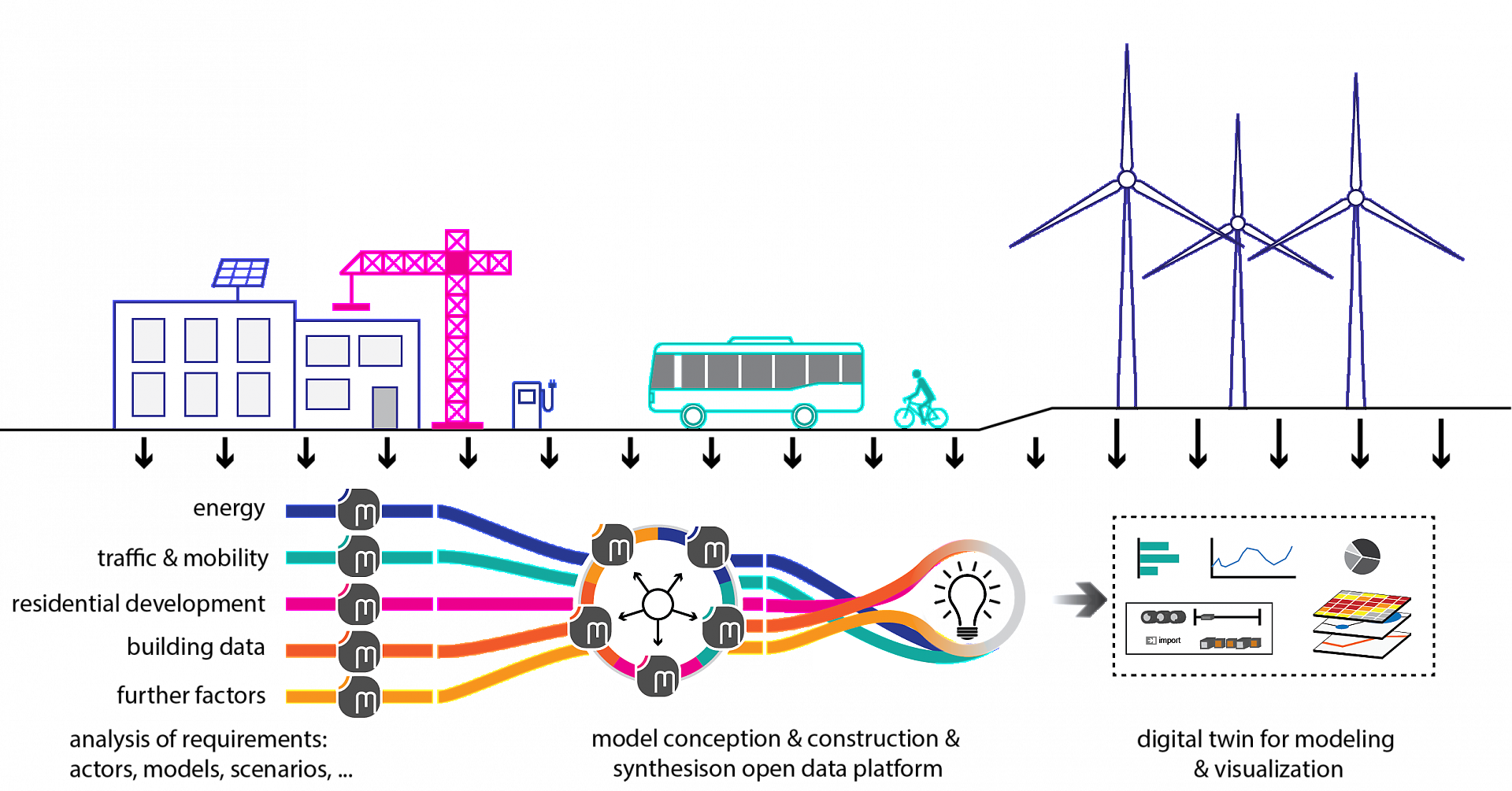
Therefore, a digital twin of the municipality of Bruck an der Leitha based on an open data model will be built for the method development, which can be used to simulate measures to improve the settlement structure within the municipality. For this purpose, forecast models for mobility, the energy network and the building stock are developed or applied and linked via the open data model in order to be able to run through development scenarios and variants based on concrete questions. The forecasting and visualisation options created in the project form the basis for the ex-ante evaluation of measures and policies on the way to a Positive-Energy-District. By identifying and collecting missing data, data gaps are filled for the simulation of precise models in the specific study area.
Methodology
The consortium is made up of experts in transport demand models and transport simulation, building and grid simulation, the energy industry, IT, and spatial planning to analyse and take into account this interaction of energy data from buildings and grids with the energy demand from mobility in planning and decision-making processes at an early stage. They drive forward methodological developments and new approaches based on concrete, practical issues. Together with representatives of the municipality of Bruck an der Leitha, the simulation scenarios and variants are developed in work package (WP) 2 and the requirements for the simulation models (energy, transport) are specified on the basis of the specific issues. They form the basis for developing the forecast models and the required data sets (WP3 + WP4).
The open data model 'SIMULTAN' already offers the possibility to store buildings with specific parameters (utilisation information, geometry, structural engineering, and building technology) as a building model. This will be supplemented with regard to the database interfaces to be able to hold the results of the traffic demand simulations and then forward them to the proof-of-concept visualisation (AP5). The meaningful data visualisation helps to discuss and evaluate the model results in cooperative and communicative processes involving different experts and stakeholders (WP6). In order to create analyses that are as practical and comprehensible as possible, stakeholders and target groups/users of a future method application are repeatedly involved in many areas of project work (WP2, WP5, WP6, WP7).
Results and Conclusions
A proof-of-concept for an intuitive decision support tool in the form of a digital, interactive 3D model will be created to examine the forecast results and the different scenarios. This will serve as a communication and decision-making tool to improve planning and policy measures to achieve energy efficient and self-sufficient settlement structures. In addition to the development of simulation model modules for specific questions about the effectiveness of changes in the settlement structure (mix of uses, mobility, ...) with regard to the energy balance of neighbourhoods, interface definitions and data descriptions for the simulation of entire settlement systems are created. The open data model allows the results of different simulation models to be compared.
Outlook
The data situation at the municipal level is a crucial issue for the sustainable planning and development of neighbourhoods. An improved database makes it possible to make well-founded decisions that contribute to achieving climate targets and energy efficiency. This is not just about collecting new data but also about combining existing data sources meaningfully. An essential aspect of data collection at the municipal level concerns the building stock. Integrating different data sources, such as information from chimney sweeps, can be a valuable source in the future. This data enables more precise statements about the energy status of buildings, heating systems, and other relevant features. Combining such sources could enable more comprehensive analyses and increase the efficiency of building management and refurbishment.
Models for generalised spatial types are needed for an efficient ex-ante evaluation to reduce the effort for municipalities when setting up models. These generalised models can be applied to different, frequently occurring structures in municipalities and can thus support a variety of planning processes. To this end, the research project 'DataScience4SmartQuarters' was submitted, which builds on the findings of the project presented here. It aims to research an innovative method for the fast and efficient evaluation of simulation scenarios (buildings/energy, mobility) for municipalities. In combination with the high-resolution simulation data and data from large-scale studies, transferable test data and models for different spatial types will be created using different data science models (e.g. ML, regression analyses, ...). By improving the data situation and integrating different sources, municipalities can be enabled to create their own scenarios and variants to better assess energy savings and infrastructure decisions.
Project Partners
Project management
TU Wien - Institute of Spatial Planning, Research Unit of Local Planning - Spatial Simulation Lab (Simlab)
Project or cooperation partners
- TU Wien - Institute of Material Technology, Building Physics, and Building Ecology - Research field building physics
- Energypark Bruck/Leitha
- y-Verkehrsplanung GmbH
Contact Address
TU Vienna
Institute of Spatial Planning, Research Unit of Local Planning
Spatial Simulation Lab (Simlab)
Karlsgasse 11
A-1040 Vienna
Tel.: +43 (1) 58801 280430
E-mail: stefan.bindreiter@tuwien.ac.at
Web: https://simlab.tuwien.ac.at